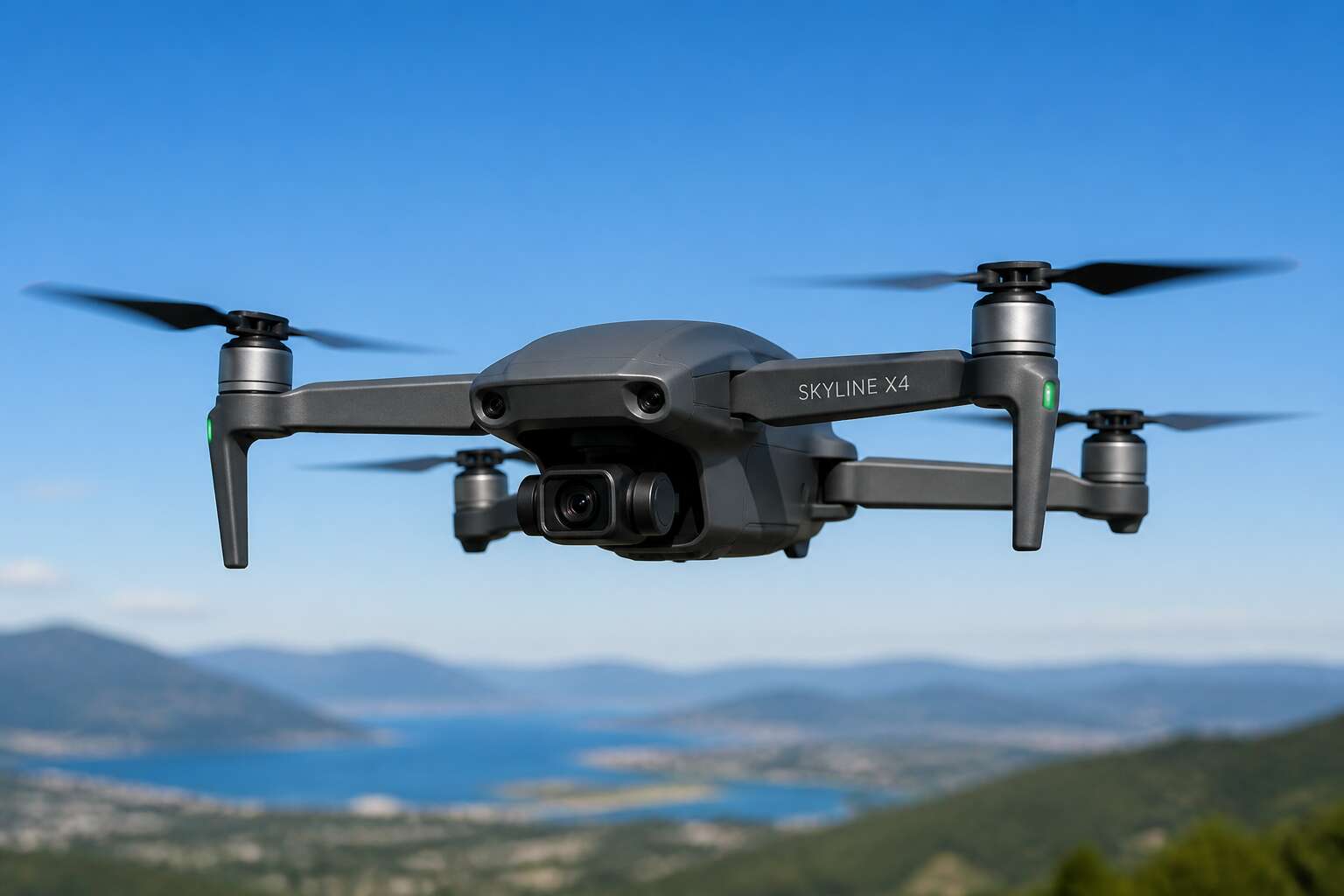
Understanding Drones
What Is an Unmanned Aerial Vehicle?
An unmanned aerial vehicle, or UAV, is any aircraft that operates without a pilot on board. The drones definition covers everything from a hand-launched quadcopter to a fixed-wing system flying beyond visual line of sight. Most people picture a camera-equipped drone buzzing over the Karoo, but the true scope is far broader.
What separates a UAV from a remote-controlled model? Autonomy. A genuine unmanned aerial vehicle follows programmed flight paths or responds to sensor data without direct human command for every manoeuvre. That distinction matters, especially when we talk about the drones definition in a legal or commercial context.
Key components of a typical UAV include:
– A flight controller that processes navigation data
– A propulsion system with motors and propellers
– A payload, such as a camera, sensor, or delivery package
In South Africa, the drones definition also carries regulatory weight. The South African Civil Aviation Authority requires registration for most commercial operations, and recreational flyers must adhere to strict altitude and proximity rules. I have watched farmers in the Northern Cape use UAVs to map water stress across vast fields, something unimaginable a decade ago. The technology evolves quickly, yet the core principle remains simple: aircraft without a human pilot, guided by software and sensors.
Core Components of a Drone
Over 1.2 million registered drones fly worldwide, yet few pilots look inside the shell. The flight controller, an inertial measurement unit with barometer and magnetometer, makes thousands of corrections per second. This processor dictates stability and navigation, shaping the drones definition in practice.
Propulsion uses brushless motors, electronic speed controllers, and matched propellers. The power distribution board routes current from the battery, while a regulator protects the autopilot from spikes. Payloads range from multispectral cameras to thermal sensors, but the frame must handle vibration and heat.
Essential subsystems include:
- Telemetry radios for real time command
- GNSS receivers for positioning
- Obstacle avoidance using lidar or stereo vision
- Data links for video and sensor logs
Each component interacts, so one failure can cascade. I have seen a loose propeller ground a mapping mission in the Free State. Precision matters! South African operators rely on these parts working together. This architecture demystifies the drones definition for every user.
How Drones Are Controlled
Pilots do not fly drones so much as negotiate with them. Every input travels through the flight controller, which interprets stick movement against wind, temperature, and battery sag. The ground control station becomes an extension of the hand. In South Africa, where gusts roll off the Drakensberg without warning, manual mode demands constant correction. Autonomous waypoint navigation shifts the pilot into a supervisor role. You program the path, then watch the aircraft hold a line through turbulence. This handoff matters. The drones definition once meant a radio controlled toy. Now it describes a system where human judgment and algorithmic response share equal responsibility. One delayed command can end a mapping run.
The Technology Behind Drones
Flight Mechanics and Propulsion Systems
Many consumer drones spin their rotors at thousands of revolutions per minute. That spin generates lift, but true flight mechanics hinge on managing opposing forces. Every drone overcomes weight, drag, and torque reaction. Propulsion systems vary by mission. Small units often use electric motors, while freighters adopt combustion engines. Here are the primary propulsion families:
- Electric motors, quiet and efficient for short range
- Gas engines, delivering endurance for long missions
- Hybrid setups, switching between power sources in flight
The drones definition extends beyond remote control; it includes these mechanical choices. Understanding a drones definition requires grasping how thrust vectors change heading. Tilting the rotor plane shifts horizontal force. This yaw, pitch, and roll combination is controlled by differential thrust. I find that a simple RPM change creates three-dimensional movement. Stability also hinges on propulsion tuning. A bad motor timing causes fatal descent. Engineers tune electronic speed controllers with care. Every rotation responds to gravity.
Navigation and GPS Technology
Over 120 satellites circle the planet, yet a consumer drone typically uses only four or five for positioning. The drones definition expands when you realise navigation is a fusion of technologies. GPS gives absolute coordinates, but a canyon or a cluster of buildings in Cape Town can block signals. That is where inertial navigation steps in. Accelerometers and gyroscopes measure every twist and turn. For drones, these sensors bridge the gaps. A barometer provides altitude, since GPS struggles with vertical accuracy. Here is how the layers stack:
– GPS for global position
– IMU for attitude and velocity
– Barometer for height above ground
– Optical flow for visual reference
Each layer corrects the others. This is what makes stable flight possible over the Karoo’s open skies. A drones definition without navigation is incomplete. The technology turns a simple camera carrier into a reliable surveyor.
Camera and Sensor Equipment
High above the Cape Winelands, a drone’s camera and sensor equipment determine what a surveyor sees. Consider the visible light sensors in consumer models, paired with gimbals that counter drone movement. Multispectral cameras capture data beyond human vision, while thermal units map temperature differences across a field. LiDAR adds precise distance measurements, turning a simple flight into a topographical survey.
I have found that sensor calibration matters as much as resolution. A poorly adjusted imager can waste an entire sortie! Here is what separates capable units:
- High dynamic range to handle harsh African sun
- Global shutter to freeze motion without distortion
- Band sensors for specific spectral analysis
These tools stream data to the controller, where software stitches frames together. Without this coordination, the drones definition remains incomplete.
Communication and Telemetry
Imagine a drone as a gossiping aunt at a family braai. It never stops sending tidbits about altitude, battery voltage, and satellite lock. That chatter is telemetry. Without it, your flying camera is an expensive kite. The communication link uses radio frequencies, often 2.4 GHz or 5.8 GHz, to carry commands down and data back. Latency matters more than range. A 200 millisecond delay turns a landing into roulette.
Modern systems use digital protocols that pack more data per packet. Some add frequency hopping to dodge Cape Town’s Wi-Fi chaos. What does the controller receive? A typical stream includes:
- Core flight data like speed and orientation
- Battery health and remaining flight time
- Signal strength and link quality
That stream completes the drones definition in practice. Without reliable telemetry, a sensor suite is useless, because you cannot trust the drone’s reports. That is the heart of any honest drones definition.
Types of Drones
Multirotor Drones
The image of a multirotor dominates any drones definition conversation. These machines generate lift from multiple spinning propellers. A quadcopter holds four rotors, while hexacopters add safety. Because they take off vertically, they need no runway. A farmer in the Free State can launch one from a bakkie to survey a field. Several configurations exist:
- Tricopters use three rotors and a swivelling rear motor.
- Quadcopters balance cost and performance.
- Hexacopters and octocopters offer redundancy for expensive cameras.
A useful drones definition must centre on their ability to hover. Multirotors trade speed for stillness. The pilot alters each rotor’s speed to tilt the craft. This creates directional thrust. The result is a flying platform that can pause over a sales event or circle a building interior. While they lack the endurance of fixed-wing planes, their agility in tight spaces is unmatched. In an urban landscape like Cape Town, that focus defines their appeal.
Fixed-Wing Drones
Fixed-wing drones challenge the notion that a hovering platform is the only template for aerial work. Their wings generate lift from forward motion, not spinning rotors. That simple distinction grants them endurance and range that multirotors cannot match. In South Africa, where vast distances separate farmland and mining sites, a fixed-wing drone can cover dozens of kilometres on a single charge. A drones definition that ignores them would remain incomplete.
This design introduces its own trade-offs. Launching requires a runway, a catapult, or a hand throw. Landing demands space and patience. Yet for long linear tasks, such as pipeline inspection or coastal monitoring, no other unmanned craft performs as efficiently. Operators trade the ability to hover for the ability to persist. The result is a fixed-wing machine suited to corridors and wide-open spaces.
Single-Rotor Helicopters
Single-rotor helicopters occupy a middle ground in any serious drones definition. They use one main rotor for lift and a tail rotor to counter torque. This configuration delivers flight endurance that multirotors cannot reach while retaining the ability to hover and land vertically, which fixed-wing aircraft sacrifice.
In South Africa, these machines carry heavier payloads across longer distances than any quadcopter. They handle high winds and thermal air currents that ground lighter systems.
Their operational realities include:
- Rotor blades requiring regular inspection and maintenance
- Training costs that exceed those for multirotor platforms
- Larger safety zones due to blade energy
These trade-offs determine where single-rotor helicopters fit in commercial fleets.
Hybrid VTOL Drones
Hybrid VTOL drones sidestep the oldest argument in unmanned aviation. They launch like a multirotor, then transition to wing borne flight once airborne. No runway, no catapult, no recovery net, yet they cover distances that battery limited quadcopters cannot manage.
For South African operators, the practical value is clear. A survey team can deploy from a farm clearing, map a 40 kilometre corridor, and land back at the same spot. Any complete drones definition has to include these machines, because they behave unlike everything that came before them.
Key characteristics:
- Vertical takeoff and landing removes launch site constraints
- Forward flight efficiency delivers extended range
- Transition mechanics demand sophisticated flight controllers
The trade off lives in the hardware. Extra motors and mounting frames add weight. Maintenance intervals shorten because the propulsion system does double duty. I have watched these platforms outwork conventional designs on real projects, but only when the flight plan respects their limits.
Nano and Micro Drones
At the smallest end of unmanned flight, size becomes a psychological variable. Nano drones weigh less than a coin. Micro drones rest in an open palm. In South African contexts, their value appears in confined spaces. A collapsed structure. A hazardous pipe. A crowded warehouse. The operator stays at a distance while these machines slip where the human body cannot follow.
Their trade-offs are severe. Battery life lasts minutes, not hours. Wind disrupts their paths. Payload barely covers a tiny camera. Yet these constraints force precision over endurance. The drones definition must include these machines because they are not miniature versions of larger craft. They have separate aerodynamics, separate control logic, separate risks.
Key characteristics include:
- Flight endurance measured in single digit minutes
- Indoor positioning systems replacing GPS reliance
- Propeller guards as standard equipment
Operating a nano or micro drone changes the operator’s relationship to flight. No spectacle. No loud motors. Just the quiet tension of controlled movement in spaces built for nobody.
Drone Applications and Use Cases
Aerial Photography and Videography
Nearly every commercial drone flight in South Africa produces images or video. Aerial photography and videography have become the dominant drone applications, from marketing farmlands to documenting weddings. Real estate agents in Johannesburg use drones to capture rooftop views and boundary lines in minutes. Filmmakers following wildlife in Kruger National Park rely on quiet propellers to avoid disturbing animals.
- Property marketing with high angle exterior shots
- Cinematic sequences for tourism campaigns
- Surveying remote terrain for mining operations
These uses show that the drones definition extends beyond flying machines. It includes the creative and commercial value they unlock. A single flight over a vineyard can reveal irrigation gaps invisible from the ground, turning a simple photograph into a diagnostic tool!
Agriculture and Crop Monitoring
A maize farmer in the Free State can launch a drone at dawn and return with a nitrogen stress map before breakfast. The drones definition in agriculture now includes multispectral sensing that detects problems before the human eye registers a colour change. Fixed-wing units cover thousands of hectares in a single sortie, returning with vegetation index maps that pinpoint pest hotspots.
Irrigation audits rely on thermal cameras that translate canopy temperature into water stress data. This reveals blocked drippers or leaking pivots without a single footprint in the soil.
- Locating citrus greening symptoms in Eastern Cape orchards
- Counting livestock density in Northern Cape rangelands
- Mapping drainage patterns after summer storms
These flights replace field-wide guesswork with precise per-tree decisions. The drones definition, in this context, rests on the data they return.
Delivery and Logistics
Delivery and logistics expand the drones definition. A courier drone carries a five kilogram parcel from a Johannesburg pharmacy to a Soweto clinic in under twenty minutes, a trip that takes a car forty minutes in morning traffic. In rural Eastern Cape, medical samples ride unmanned aircraft across rivers that wash out roads each rainy season. I have watched a drone drop a package into a clinic courtyard with centimetre accuracy.
- Emergency medicine delivery to accident scenes
- E commerce parcels for suburban customers
- Vaccine transport with cold chain monitoring
Each flight is a small exercise in practical engineering. Payload, range and reliability shape what is possible. Weather sensing, obstacle avoidance and precise landing matter more than camera quality.
Search and Rescue Operations
Search and rescue operations stretch the drones definition further. On Table Mountain, a hiker with a broken ankle spent the night before a thermal camera spotted her from above. The drone operator, working with the Wilderness Search and Rescue team, guided ground crews to her exact location. What took older methods two days in dense fynbos took four hours from launch site to evacuation.
The drones definition in this context is about sensors, not cameras. Thermal imaging reads body heat at night. GPS coordinates feed directly into rescue co-ordination. Small quadcopters navigate gorges where helicopters cannot safely fly.
A typical coastal rescue flight involves:
Locating a swimmer caught in a rip current off Muizenberg beach
Dropping a flotation device within reach
Maintaining visual contact until the NSRI rubber duck arrives
Each rescue rewrites the meaning of drones definition. The person waiting for help matters more than the flight itself.
Infrastructure Inspection
A single cracked pylon on a transmission line can darken a whole suburb. Precision observation of steel, concrete, and cable under load expands the drones definition. I have seen thermal signatures reveal a failing bearing on a wind turbine before any vibration was audible. Infrastructure inspection now sends quadcopters along bridge soffits, into mine shafts, and across dam walls. They capture millimetre-level detail without shutting down operations.
A typical transmission line inspection follows:
- Fly a pre-programmed route along the conductors.
- Capture high-resolution images from multiple angles.
- Analyse corrosion, bird damage, or vegetation encroachment.
Access and repeatability define this context. We return every month to the same coordinates, comparing data over time. That consistency turns a single flight into a historical record.
Recreational Flying
Recreational flying reveals the drones definition in its purest form. I have watched a sunset turn a quadcopter into a silhouette against the Karoo sky, and that moment carries as much technical wonder as any industrial survey! For hobbyists, this context shifts from inspection tool to personal viewing device.
Flying for leisure demands respect for airspace and neighbours. South African regulations require registration and line of sight, but the payoff is immediate. You can trace a coastline, chase a breeze, or hover above your own backyard.
- Throttle control in open fields
- Wind pattern reading
- Battery limit testing
Each flight builds your understanding through direct experience.
Drone Regulations and Safety
FAA Rules and Registration Requirements
The rapid growth of consumer drones has outpaced regulation. The FAA oversees more than 800,000 registered recreational drones. Every drone weighing over 250 grams must be registered, and this applies to recreational and commercial pilots alike. Failure to register can result in fines.
The FAA’s Part 107 rules govern commercial drone operations. Pilots must pass a written exam and renew their certification every two years. Flight restrictions apply near airports and over crowds. The agency also enforces a 400-foot altitude ceiling for most operations.
Registration requirements include:
- A $5 fee per aircraft
- A three-year validity period
- A visible registration number on the drone
South African pilots follow similar rules under the SACAA, which models many regulations on the FAA framework. Understanding the drones definition becomes essential when determining which rules apply to your specific aircraft. The drones definition under FAA rules excludes toys below the 250-gram threshold, which simplifies compliance for casual users.
Licensing and Certification for Pilots
Every year, thousands of aspirants sit for South African Civil Aviation Authority exams, and a third fail on their first attempt. That failure rate reveals something essential. Licensing is not administration. It is a psychological threshold.
The drones definition becomes personal when you hold a Remote Pilot Licence. This legal definition determines what you can fly and what happens when something goes wrong. SACAA demands theoretical knowledge across meteorology, air law, and human performance. Then comes the flight test, where examiners watch how you manage stress alongside stick skills.
Certification renews every 24 months, which keeps your knowledge current. FAA data links most incidents to pilot error rather than equipment failure.
The licensing process, built on the drones definition, covers:
- Airspace classification and clearance procedures
- Emergency procedures for signal loss and flyaways
- Decision making under pressure
Each licence binds your identity to the machine. That accountability changes how you fly.
Privacy and Ethical Concerns
South African drone regulations extend beyond the Civil Aviation Regulations. The drones definition in law creates obligations around privacy, ethics, and airspace. When a drone carries a camera, it becomes a surveillance instrument. The POPI Act imposes limits on how imagery is collected and stored.
Safety concerns follow the same logic. A pilot who grasps the legal definition understands that risk is distributed. Flying near crowds, schools, or critical infrastructure demands judgement no manual can fully codify. I have seen operators overlook privacy rules until a complaint lands on their desk.
- Respect no-fly zones near airports and prisons
- Obtain consent before recording people
- Report incidents to the SACAA promptly
Ethical practice means treating the drone as a tool with consequences, where privacy and safety converge.
No-Fly Zones and Airspace Restrictions
In South Africa, the drones definition in the Civil Aviation Regulations sets the baseline, but airspace restrictions add another layer. The SACAA designates no-fly zones around airports, prisons, and power stations. These are not suggestions! A pilot who ignores them faces fines or criminal charges.
Understanding this definition helps you see why these zones exist. I have seen pilots treat no-fly zones as optional. A drone is an aircraft, even a small one. It shares airspace with manned planes. The risk of collision is real, and the law treats it seriously. Common restricted areas include:
- Airports and airstrips
- National key points
- Prisons and police stations
The SACAA’s digital map is essential before every flight. Airspace restrictions change with events like fires or VIP movements. The legal definition does not cover every local rule, so local bylaws still apply.
Drone Terminology and Concepts
Understanding First-Person View
First-person view strips away every abstraction. There is no joystick, no separation. The drone’s camera becomes your eyes, and the world rushes through a video feed without delay.
- “Latency” measures the silent gap between the camera’s capture and your retina.
- “Signal penetration” reveals how many walls, trees, or shadows stand between you and the machine.
- “Field of view” dictates whether you see the whole horizon or only a narrow maw of space.
A useful drones definition must account for this sensory loop. Pilots fly beyond line of sight while remaining suspended inside the aircraft’s perspective. The result is a peculiar trust between human and machine, established over the thinnest thread of radio waves.
Gimbal Stabilization Explained
Any accurate drones definition includes gimbal stabilization. This mechanism keeps the camera level while the aircraft tilts, pitches, or rolls. Three small motors counter every movement in real time. The result is smooth footage even in gusty South African winds.
Consider what happens without a gimbal. Every vibration from the rotors reaches the lens. I have watched entire survey missions fail because of this. A gimbal acts as a physical buffer between the drone’s motion and the camera’s orientation.
- Two-axis gimbals correct tilt and roll.
- Three-axis gimbals add yaw correction for complex flights.
Stability is not a luxury! It is the difference between usable data and wasted flight time.
Flight Time and Battery Life
Battery life ends more flights than pilot error. The average consumer quadcopter manages around 30 minutes per charge, and that number drops sharply in South African heat or gusty conditions. A proper drones definition must account for this constraint, because endurance dictates what missions are even possible.
I have watched pilots swap batteries six times just to cover one small vineyard. Capacity is only part of the equation. Key factors include:
- Battery weight relative to thrust
- Propeller pitch and motor draw
- Hovering versus sustained forward flight
Voltage sag appears as the pack depletes. The last 20 percent always feels like a countdown. Ground effect extends flight slightly near surfaces. Payload steals minutes, not seconds. Treat battery life as the real payload.
Range and Signal Strength
Range and signal strength define the operational limit between pilot and machine. A proper drones definition must account for this limit, because exceeding the link means losing the aircraft! In South Africa, the Highveld’s rocky ridges can disrupt a 2.4 GHz control link far sooner than any spec sheet suggests.
Signal strength decays with distance, but obstacles like koppies or dense eucalyptus groves scatter radio waves unpredictably. I have seen a clean, open-field connection drop at 400 meters while a cluttered suburb held stable at 700 meters. Interference from cell towers, power lines, and even solar flares plays havoc with these links.
- Check the signal quality as a percentage instead of bars
- Test your failsafe behaviour before relying on it
Autonomy and Waypoint Navigation
Autonomy makes a drones definition more than a technicality. Waypoint navigation lets a pilot plot coordinates, then the aircraft visits them in sequence. The pilot becomes supervisor, not driver. South African land managers use this to survey fencelines or inspect pivots without manual stick work.
The real distinction lies in how much decision making the system does. Consider the autonomy scale:
- Level 1: Manual flight, every command from the pilot
- Level 2: Assisted, stability controls active
- Level 3: Waypoint following, with human override available
- Level 4: Fully autonomous, including obstacle avoidance
A waypoint is a GPS coordinate, but the logic connecting them shapes the flight. Some systems stop at each point; others predict the next turn. Read the fine print about how the drone handles a lost link or a blocked path. That is where a drones definition becomes essential.

0 Comments